Figure 1 - The Franklin Piloting Technique
CORRECTING FLAWS IN THE ART
OF NAVIGATION
By Master Chief Byron E. Franklin, U.S. Navy
(Retired)
| Master Chief Byron Franklin was a Quartermaster for 26 years on various surface ships and nuclear submarines before retiring in 1978. Two navigation techniques bearing his name --- the Franklin Piloting Technique and the Franklin Continuous Radar Plot---are currently published in navigation texts and training materials. He was awarded the Navy Commendation Medal for his work with the Naval Oceanographic Office on plotting, as well as in radar, celestial, and radio navigation evaluation and recommendations. |
Despite the efforts of the Navy to improve the proficiency of its piloting teams, an insidious, built in deficiency in the practice of navigation in hazardous pilot waters will persist until the Navy's higher echelons and training schools recognize the problem and take corrective action.
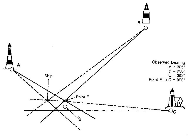
Figure 1 - The Franklin Piloting Technique
|
The fix is placed in the center of the triangle formed by the (solid) lines of position (LOPs). If the triangle is too large, the navigator may find the error by juggling the bearings. But if the fix is selected at the intersection of the two closest aids (Point F), a bearing from Point F to the farthest aid (Point C) would produce the 4 degree error. The triangle collapses when the 4 degrees is added to the LOPs; the dash line represents the line-of-sight and the corrected, true bearings |
The problem is that, generally, we believe that we have to live with navigation triangles---triangles of error. This comes from the attitude that point fixes, or small triangles, are just luck, or that they are text book exercises not related to the real world. This may be true in celestial navigation, but not in piloting.
This attitude is induced by navigation texts and training courses, which, when treating the cross-bearing plot, state that one should take the center of the triangle as the fix. Some books and courses go on to state that one should use trial and error when the triangle is uncomfortably large.
Actually, one must accept only the smaller triangles of error. To avoid making bad recommendations based on the large triangles, one only needs to apply the Franklin Piloting Technique. (See Nathaniel Bowditch, American Practical Navigator, Article 1009, Volume I, Pub. No. 9.) This provides a less confusing and more accurate plot on which to base recommendations.
Paradoxically, considering the flawed attitude, the ploting team puts a lot of effort into trying to collapse the triangle on the next round of bearings....and the next....This efficient effort requires so much of the navigator's (and his plotting team's) attention that other important matters are neglected. There is much more to piloting than just being able to produce a high-quality cross-bearing plot. Even with a good plot, sound recommendations to conn require considerable knowledge and experience. The experienced navigator who is aggravated by the quality of his plot cannot perform up to his potential. He will be unable to stay ahead of the immediate situation and will be unprepared for the unexpected.
Another way training materials contribute to the flawed attitude is in their treatment of error specifications. The error specifications of certain gyrocompasses indicate that their use as a heading reference in cross-bearing plotting will result in a triangle even when there are no small random errors in the bearing observation. In the treatment of azimuths of the sun for finding gyro error, most navigation texts and training materials state that if the error is calculated to be 0.5 degrees, it can be considered zero. No doubt this reflects certain errors made in observations and rounding off errors, particularly when tables are used for the calculation. However, after the ship gets under way and is subjected to accelerations that affect the gyro and for which the gyro imperfectly compensates, the error could become greater.
Perhaps too little attention is given to the fact that an azimuth of the sun is a crude way to check for gyro error. One of many factors affecting the precision of this method is the somewhat thick band of reflected light from the sun. Although not a common problem, the mirror of the azimuth circle could be out of alignment. If so, it could indicate that there is no gyro error, but leave you with large triangles when you shift to the bearing circle and plot on the chart. From my experience, it is unwise to use the azimuth circle to find and correct the gyro system error.
After having just arrived on board an aircraft carrier as
senior chief quartermaster, I found the gyro error to be 1.5 degrees east by
using the Franklin Piloting Technique. The azimuth placed the error at
nearly zero. To plot with pinpoint accuracy, we used the 1.5 degree east
error correction and did not adjust the gyro until sophisticated triangulation
from the beach agreed with the 1.5 degree error and, of course, disagreed with
the azimuth. I took the ship's azimuth circle to the tender where the 1.5
degree error was detected in the circle. Apparently, the yard/overhaul had
used the faulty azimuth circle to align the system. This was not the first
time that I had run into this problem. But
it was the last time from 1959 aboard the Outpost or any other ship that I
served on when navigation aids were available that an azimuth of the sun was
given precedence in determining gyro error.
From 1959, when I began developing my system, until I retired in 1978, I encountered no gyro problems that I could not solve quickly and mechanically. My system also helped others on more than one occasion. For example, a unit commander became troubled by small triangles passing over a string of buoys on the chart made by his very competent people. His faith in the navigational skills of a new submarine's crew prompted him to have the position of the buoys checked. The conn had stated that they went down the middle of the channel. Using my technique, I quickly established that, indeed, the sub had the gyro error noted by the triangles, and did go down the center of the channel as conn stated.
Another navigation flaw is the failure to consistently analyze problems encountered during a transit of hazardous waters. Unfortunately, the charts in use are too quickly erased and stowed for future use. This practice should be changed to prevent the same mistakes from being made over and over. This need not be done immediately after the transit. The charts and associated records could be set aside until operations permit their inspection and evaluation.
Generally, it may be true that somewhat sloppy work will not endanger the ship. Inevitably, however, the time comes when a more accurate plot is absolutely necessary. Each transit should be used as a training exercise for difficult transits; the goal should be high-quality piloting at all times. Addressing these two navigational deficiencies will result in more accurate plots, more time to stay ahead of the navigational big picture, and the opportunity to benefit from prior mistakes.
THE VERTICAL SEXTANT
This tip will enable even the inexperienced celestial navigator to plot celestial fix pinwheels on the chart by using a simple sextant technique.
In 1958, I was stationed on a liberty
ship (USS Outpost AGR-10)
of World War II vintage. For five years, the ship was under way
approximately 200 miles off the East Coast using Loran "A" and the
sextant to maintain a radar, aircraft and missile tracking station.
The duty was a pleasure for a celestial navigation nut like myself because in
any month I observed, computed, plotted and evaluated 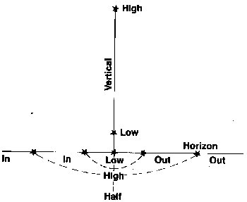 an
average of 20 morning and evening star fixes, plus countless sun lines.
an
average of 20 morning and evening star fixes, plus countless sun lines.
The best fixes were always when the horizon was fully lit, toward the day side of twilight. Once the stars became bright, the horizon would darken and become a thick band. The best plan was to sight while the stars were just showing, bring the star to the sharp horizon, swing the star (rock the sextant), and lay the star on the horizon. Many times, especially with a high star, the star would disappear on or near the well-lit horizon.
The sky just above the horizon is lighter than the rest of the sky and the swinging takes away some of the concentration needed to stay locked onto the faint star or the pale disk of a planet. In order to sit that faint star on the distinct horizon with bringing the faint star into the relatively darker water and rocking the sextant, watching the star enter and leave (in and out) the water.
I found that I could quickly isolate the exact point under the star "Vertical Sextant," be it high or low. I could concentrate on putting the star on the horizon by halving the "in and out" mentally and bringing the star above that point on the horizon and then coming down for the mark. It worked so well for me that I started using the same procedure for the sun and bright stars. Very accurate fixes were easy.
I admit that my celestial fixes were
not so accurate after a transfer to duty with less demanding celestial
navigation practice. When I shifted back to "Vertical Sextant"
(in and out of the water), my fixes would improve and tighten with no random
near misses. Give the technique a good try.
Back to USS Searcher Home Page